Article

Avena fatua L.

Wild oat
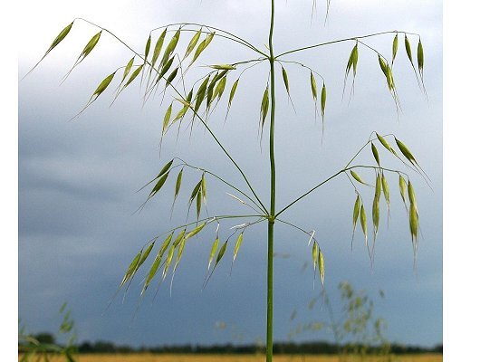
source: Christian Fischer (2007) publisher: Wikimedia Commons (license CCASA 3.0 Unported)

Nomenclature

GrinTax Avena fatua L.
The Plant list Avena fatua L.
English name Wild oat


Crop relationship
Oat primary genepool


FLORON data (2014)
Indigeneity naturalized before 1500
Trend since 1950 decreasing (25-50%)
Presence relatively rare
Status Red List: near threatened
Legal protection unlisted

Conservation in the Netherlands

A) In protected areas per province

For subareas the link to the larger area is provided.

a = actually present, p = possible
(see: About CWRnl / Methodology)

Drenthe

  • Boswachterij Schoonloo (SBB [p])
  • De Klencke (NM [p])
  • De Witten (SBB [p])
  • Drentsche A-Oudemolen (SBB [p])
  • Leggelderveld (NM [a])
  • Nationaal Park Dwingelderveld (NM [a])
  • Veenstreek (SBB [p])

Flevoland

  • Fluitbos (SBB [p])
  • Horsterwold (SBB [p])
  • Oostvaardersplassen (SBB [p])
  • Swifterbos (SBB [p])

Friesland

  • Littenseradiel (SBB [p])
  • Nationaal Park Schiermonnikoog (NM [p], SBB [p])
  • Noordwesthoek (SBB [p])

Gelderland

  • Bergherbos (NM [a])
  • Bronkhorst (SBB [p])
  • Buren (SBB [p])
  • Duivelsberg (SBB [p])
  • Epe (SBB [p])
  • Gorssel (SBB [p])
  • IJsselwaarden Noordwest (SBB [p])
  • IJsselwaarden Zuidwest (SBB [p])
  • Meinerswijk-Lingezegen (SBB [p])
  • Sint Andries (SBB [p])
  • Tielerwaard Komgronden (SBB [p])
  • Waarden bij Heesselt (SBB [p])
  • Wageningse Uiterwaarden (SBB [p])

Groningen

  • Dal van de Ruiten A (NM [p])
  • Duurswold (SBB [p])
  • Noord- en Zuidbroek (SBB [p])
  • Veelerveld (SBB [p])
  • Westerwolde (SBB [p])

Limburg

  • Annendaalsbos (SBB [p])
  • Bergerbos (SBB [p])
  • Bergjes (SBB [p])
  • Brunssummerheide (NM [p])
  • Bunderbos (SBB [p])
  • Dal van de Roode Beek (NM [p])
  • Den Ouden Bosche (SBB [p])
  • Geleenbeekdal (NM [p])
  • Genhoes (NM [p])
  • Gerendal (SBB [p])
  • Geul- en Gulpdal (SBB [p])
  • Grasbroek (NM [p])
  • Heuloerbroek (SBB [p])
  • Kunderberg (SBB [p])
  • Limbrichterbos (NM [p])
  • Maasoevers Limburg (SBB [p])
  • Maasvallei (NM [p])
  • Mechelderbeekdal (NM [p])
  • Platsbeekdal (NM [p])
  • Ravensbos (SBB [p])
  • Roerdal (SBB [p])
  • Savelsbos (SBB [p])
  • Schinveldse Bossen (NM [p])
  • Sint-Jansberg (NM [p])
  • Sint-Pietersberg (NM [a])
  • St. Jan Sleutelbergbos (SBB [p])
  • Swentiboldse Land (SBB [p])
  • Tungelerwallen (NM [p])
  • Vaals (SBB [p])
  • Wahlwiller Graven (SBB [a])
  • Wintrakerberg (SBB [p])
  • Wormdal (NM [p])

Noord-Brabant

  • Breugel (SBB [p])
  • Chaam (SBB [p])
  • Cuijkse Land (SBB [p])
  • De Biesbosch (SBB [p])
  • Gooren en Krochten (SBB [p])
  • Kasteren (SBB [p])
  • Keent en Reek (SBB [p])
  • Langstraat (SBB [p])
  • Leudal (SBB [p])
  • Maasuiterwaarden (NM [p])
  • Middelsteegse Weiden (SBB [p])
  • Moerdijk (SBB [p])
  • Overloon (SBB [p])
  • Prinsland (SBB [p])
  • Tolbergse Schuurkapel (NM [p])
  • Westelijke Beemden (SBB [p])
  • Willemstad (SBB [p])
  • Zonzeel (SBB [p])

Overijssel

  • Buurserzand (NM [p])
  • Dinkelland (SBB [p])
  • Engbertsdijksvenen (SBB [p])
  • Nationaal Park De Sallandse Heuvelrug (NM [p])
  • Sallandse Heuvelrug (SBB [p])
  • Springendal (SBB [p])

Utrecht

  • De Vuursche (SBB [p])
  • Fort Nieuwersluis (NM [p])
  • Polder Groot-Mijdrecht (NM [p])

Zeeland

  • Braakman (SBB [p])
  • De Poel (NM [a])
  • Grevelingen (SBB [p])
  • Hontenisse-Hulst (SBB [p])
  • Voornes Duin (NM [a])
  • Walcheren (SBB [p])
  • West-Zeeuws-Vlaanderen (SBB [p])
  • Zuid-Beveland (SBB [p])

Zuid-Holland

  • De Haaglanden (SBB [p])
  • Hoeksche Waard (SBB [p])
  • Leidschendammerhout (SBB [p])
  • Oeverlanden Hollands Diep (SBB [p])
  • Valckestein (SBB [p])
  • Wassenaar (SBB [p])

B) In genebank

  • CGN: no material

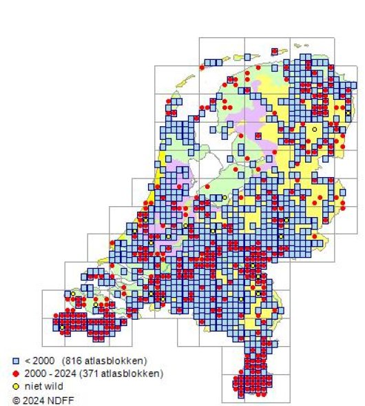
© NDFF, 2015
© NDFF, 2015

Legend distribution maps

upper map:

  • red: locations of presence
  • green: management type maps with areas that qualify for financial support (largely representing the Dutch network of protected areas). Protected water areas are not shown (IJsselmeer, Markermeer and all Frisian lakes, Randmeren & Vechtplassen).

- - - - - - - - - -

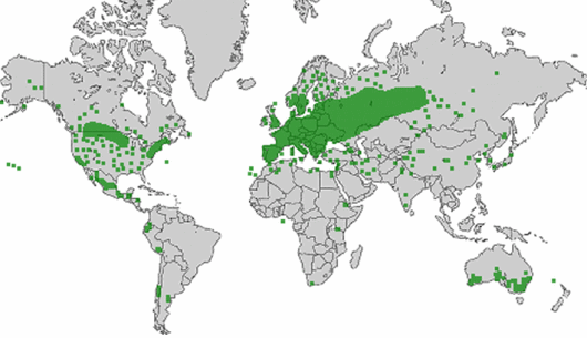
lower map:

Distribution area
Europe from temperate zones to cold regions
Asia in temperate zones
Africa in temperate zones
North-America from temperate zones to cold regions
South-America in temperate zones
Australia in temperate zones
source: wilde-planten.nl, 2015

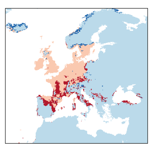
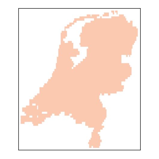
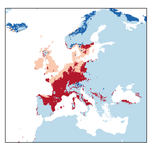
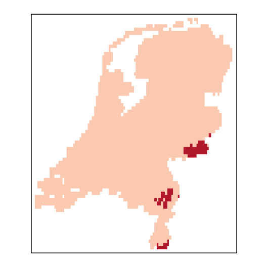
Expected distribution due to climate change

Expected distribution area in 2070 in the European region and in the Netherlands compared with current suitable areas under an optimistic and a pessimistic climate change scenario (see: About CWRnl / Methodology). Click on a map to enlarge.

legenda_uk.gif

Optimistic scenario

Avenafatua_EU_C26-small.png
Avenafatua_NL_C26-small.png
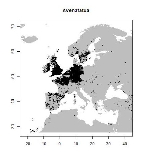
Distribution data GBIF, June 2016. doi:10.15468/dl.cntxl0

Pessimistic scenario

Avenafatua_EU_C85-small.png
Avenafatua_NL_C85-small.png

Additional information